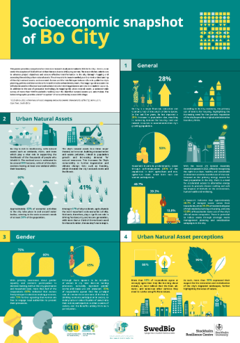
IMPACT AREA 2 - ICLEI Africa

IMPACT AREA 2

Mainstreaming nature in decision-making and planning

Across Africa, cities face the dual pressures of rapid urbanisation and climate risk, which place a growing strain on ecosystems and people. Yet, nature provides essential services, such as flood mitigation, cooling and water regulation, which are critical for long-term urban resilience. Historically, nature’s contributions to people have been undervalued or overlooked in core city planning systems and decision-making processes.


The UNA project helped shift this narrative by positioning nature as essential urban infrastructure and promoting nature-positive urban development. Through planning tools, spatial data integration and cross-sector collaboration, cities were supported to embed nature into land use planning, governance and decision-making. This mainstreaming approach helps cities design for resilience, reduce biodiversity loss and align with broader sustainability agendas.

2a

Bridging data gaps: Supporting cities in evidence-based decision-making

Many cities in Africa lack the data needed to inform data-driven policies and make informed decisions related to biodiversity, city planning and climate action. Throughout the UNA project, great efforts were made to close this data gap and provide cities with the information they need to make informed decisions. By co-producing products such as natural asset maps, climate risk assessments, roadmaps and socio-economic assessments with city stakeholders, the project equipped cities with practical resources to guide data-driven, contextually relevant actions and investments. 

Case studies

Through the UNA Rivers for Life project, Kampala, Uganda embedded nature into its urban planning systems by co-producing natural asset hotspot maps with local and national stakeholders. These maps identified key areas that need protection based on their vulnerability to climate risks and urban development pressures, as well as the essential ecosystem services they provide, such as flood regulation, water purification, and biodiversity support. They are now being used in everyday decision-making. The process built cross-departmental relationships and clarified institutional roles, improving coordination and trust. The maps and resulting recommendations have been integrated into the City’s Resilience Strategy, influencing planning, water management and climate adaptation efforts.


Learn more below:

Between 2022 and 2023, the UNA project invested in city-wide natural asset mapping in Bo City, Sierra Leone and Cape Coast, Ghana. This process enabled cities to answer four key questions: (i) Which natural assets exist? (ii) Where are they located? (iii) What condition are they in? and (iv) What threats are they facing? This information helped facilitate informed planning, decision-making and financing. To give cities a more holistic picture of the socio-economic dynamics and their implications on livelihoods and natural assets, mapping and data collection was extended to the socio-economic landscape. The socio-economic survey undertaken in both project cities focused on understanding the socio-economic landscape and assessing the interlinkages between people’s day-to-day activities, the economy and the environment. The survey focused on several different thematic areas, including household characteristics, economic profiles, gender dynamics, attitudes toward nature and people’s relationship with nature. This deeper understanding helped shape contextually relevant strategies and actions in both cities.


Learn more below:

Socio-economic snapshot: Bo City

Socio-economic snapshot: Cape Coast

2b

Empowering cities to leverage finance for nature

Central to mainstreaming nature into decision-making and planning has been the project’s targeted support for developing financial capacity. By adopting a whole-of-society approach that actively involves city officials, technical practitioners, communities, researchers and traditional leaders, the UNA project equipped local actors with the tools, knowledge and confidence needed to access and mobilise funding for NbS. This ensures that resources reach the areas where they are most needed to address locally identified priorities.

Case study

Under the UNA Resilience project, Bo City and Cape Coast received support to strengthen their understanding of biodiversity finance and explore pathways to access it. Tailored in-person learning labs, detailed finance flow assessments and co-created finance training modules helped more than 80 stakeholders understand and apply biodiversity finance concepts effectively. Resources such as a finance handbook, infographic and guide were developed to support this learning. As a result, both cities are now better equipped to align urban planning with nature and design and implement sustainable finance strategies that benefit people, ecosystems and local economies. This work was carried forward into the next phase, UNA Embed, which included all cities from prior projects. A key focus was helping cities refine strong concept notes for investment in NbS and providing further capacity-building to support access to finance.

2c

Planning with nature

Through the UNA project, cities moved beyond seeing nature as an add-on to urban development and embedded it directly into planning systems, spatial frameworks, governance systems, decision-making and resource mobilisation. From coastal zones to wetlands, municipalities have been supported to identify, map and integrate natural assets into local development plans in ways that are inclusive, strategic and actionable. This approach empowered diverse stakeholders to co-design shared priorities for managing and protecting ecosystems, while aligning local planning with resilience goals.

Case study

In Nacala, Mozambique, the project brought together city officials, technical departments and community representatives to co-develop a Coastal Natural Asset Management Plan (CNAMP). This inclusive process identified key coastal assets, outlined their benefits and threats and set out clear goals, actions, responsibilities and financing options. The plan is more than a policy tool; it’s a shared roadmap that empowers local actors with the knowledge and agency to manage their coastline sustainably. Because it was built collaboratively, the CNAMP helped to foster more coordinated, cross-departmental engagement on nature-related initiatives.


Nacala City is currently prioritising coastal mangrove restoration and capacity-building, particularly for municipal officials, to enhance coastal natural assets to support climate change mitigation and adaptation, in line with the CNAMP.


Learn more:

Pathway resources

Mainstreaming nature in decision-making and planning

UNA finance guide

Socio-economic snapshot: Cape Coast

Socio-economic snapshot: Bo City

Illustrated map: Cape Coast

Illustrated map: Bo City

Poster: Introduction to biodiversity finance

Impact story 2: Practice reform

Impact story 3: Mainstreaming in practice

UNA biodiversity finance handbook

Case study: Working with nature to reduce disaster risk in Africa

Handbook 7: The importance of relationship building

Handbook 9: Prioritising processes: Bridging the divide between different sectors and disciplines

ICLEI Africa

ICLEI - Local Governments for Sustainability is a global network working with more than 2500 local and regional governments committed to sustainable urban development. Active in 125+ countries, we influence sustainability policy and drive local action for low emission, nature-based, equitable, resilient and circular development.

Subscribe to our News

iclei africa & initiatives
Stay in the loop

Sign up to our newsletter

Sharing impactful, innovative and inclusive action in African cities and regions